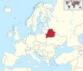
File:Belarus in Europe.svg

Size of this PNG preview of this SVG file: Amachashazikazi ama-701 adlulayo nama-599 amile. Other resolutions: Amachashazikazi ama-281 adlulayo nama-240 amile | Amachashazikazi ama-561 adlulayo nama-480 amile | Amachashazikazi ama-898 adlulayo nama-768 amile | Amachashazikazi ama-1,198 adlulayo nama-1,024 amile | Amachashazikazi ama-2,395 adlulayo nama-2,048 amile | Amachashazikazi ama-1,401 adlulayo nama-1,198 amile.
Ifayela ewu ngqo (SVG file, nominally 1,401 × 1,198 pixels, file size: 2.61 MB)
Umlando womqulu
Click on a date/time to view the file as it appeared at that time.
| Usuku/Isikhathi | Isithonjana | Dimensions | Umsebenzisi | Amazwana | |
|---|---|---|---|---|---|
| Njengamanje | 03:56, 12 uNtulikazi 2016 |  | 1,401 × 1,198 (2.61 MB) | Stasyan117 | Dotted line between Ukraine and Crimea |
| 14:05, 17 uNdasa 2011 |  | 1,401 × 1,198 (4.04 MB) | TUBS |
Ukusetshenziswa komqulu
The following page uses this file:
Ukusetshenziswa komqulu jikelele
Amanye ama-wiki asebenzisa lefayela
- Ukusetshenziswa ku-ang.wikipedia.org
- Ukusetshenziswa ku-csb.wikipedia.org
- Ukusetshenziswa ku-de.wikipedia.org
- Ukusetshenziswa ku-dz.wikipedia.org
- Ukusetshenziswa ku-frr.wikipedia.org
- Ukusetshenziswa ku-fr.wikipedia.org
- Ukusetshenziswa ku-hsb.wikipedia.org
- Ukusetshenziswa ku-hu.wiktionary.org
- Ukusetshenziswa ku-ig.wikipedia.org
- Ukusetshenziswa ku-incubator.wikimedia.org
- Ukusetshenziswa ku-lg.wikipedia.org
- Ukusetshenziswa ku-lv.wikipedia.org
- Ukusetshenziswa ku-mg.wikipedia.org
- Ukusetshenziswa ku-nds-nl.wikipedia.org
- Ukusetshenziswa ku-nl.wikipedia.org
- Ukusetshenziswa ku-os.wikipedia.org
- Ukusetshenziswa ku-pl.wikipedia.org
- Ukusetshenziswa ku-ru.wikinews.org
- Ukusetshenziswa ku-sr.wikibooks.org
- Ukusetshenziswa ku-www.wikidata.org
- Ukusetshenziswa ku-zh.wikipedia.org


