
File:Koppen-Geiger Map ARG present.svg

Size of this PNG preview of this SVG file: Amachashazikazi ama-512 adlulayo nama-423 amile. Other resolutions: Amachashazikazi ama-291 adlulayo nama-240 amile | Amachashazikazi ama-581 adlulayo nama-480 amile | Amachashazikazi ama-930 adlulayo nama-768 amile | Amachashazikazi ama-1,240 adlulayo nama-1,024 amile | Amachashazikazi ama-2,479 adlulayo nama-2,048 amile.
Ifayela ewu ngqo (SVG file, nominally 512 × 423 pixels, file size: 1.21 MB)
Isifinyezo
| Incazelo |
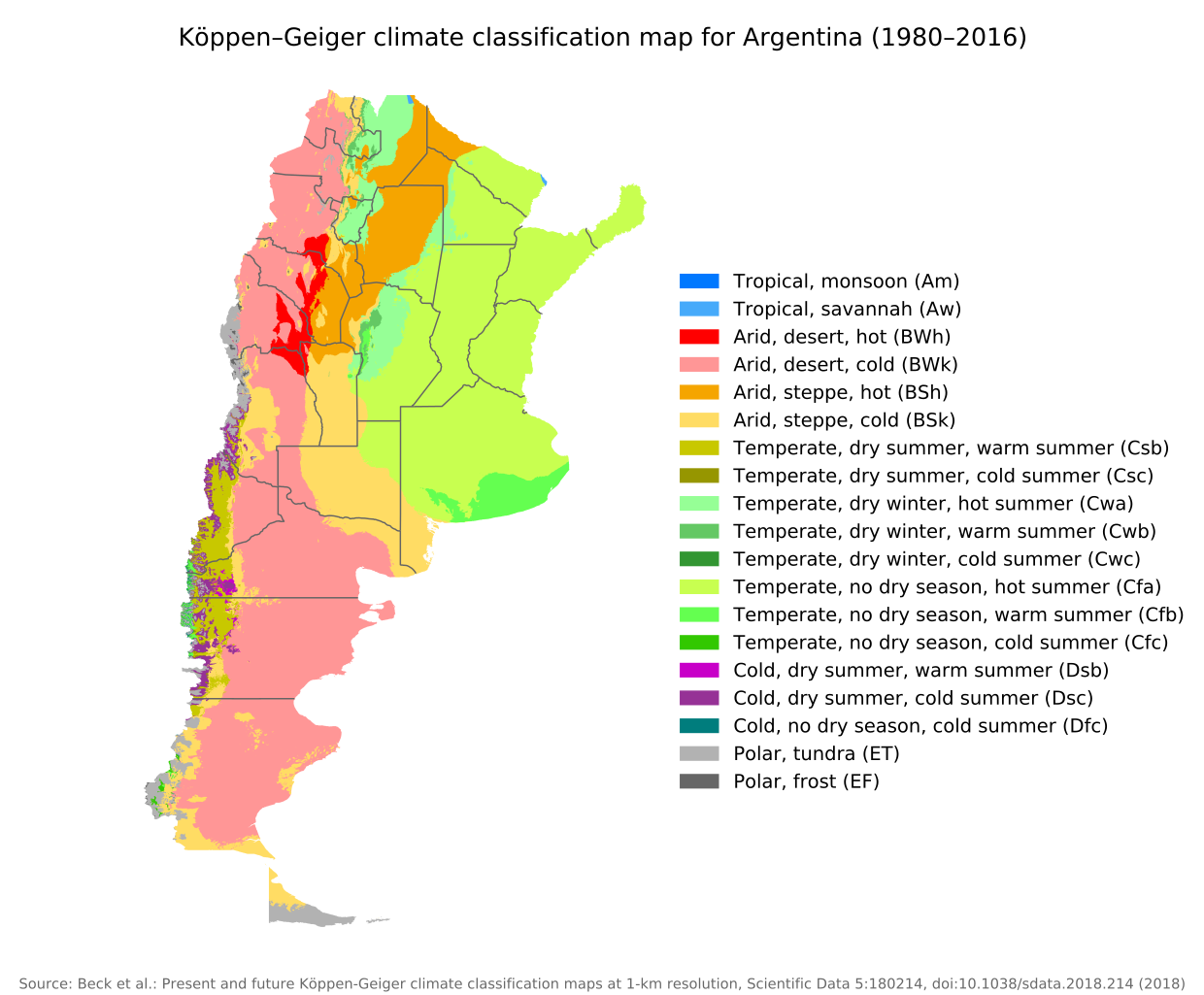
English: Köppen–Geiger climate classification map for Argentina |
| Usuku | |
| Umthombo | "Present and future Köppen-Geiger climate classification maps at 1-km resolution". Nature Scientific Data. DOI:10.1038/sdata.2018.214. |
| Umlobi | Beck, H.E., Zimmermann, N. E., McVicar, T. R., Vergopolan, N., Berg, A., & Wood, E. F. |
Licensing
This file is licensed under the Creative Commons Attribution 4.0 International license.
- Ukhululekile:
- ukwabelana – to copy, distribute and transmit the work
- to remix – to adapt the work
- Ngaphansi kwezimo ezilandelayo:
- attribution – You must give appropriate credit, provide a link to the license, and indicate if changes were made. You may do so in any reasonable manner, but not in any way that suggests the licensor endorses you or your use.
| Camera location | | View this and other nearby images on: OpenStreetMap |
|---|
Umlando womqulu
Click on a date/time to view the file as it appeared at that time.
| Usuku/Isikhathi | Isithonjana | Dimensions | Umsebenzisi | Amazwana | |
|---|---|---|---|---|---|
| Njengamanje | 09:14, 8 uMandulo 2020 | | 512 × 423 (1.21 MB) | Allice Hunter | Provinces and adjustments |
| 15:44, 17 uNtulikazi 2020 |  | 1,208 × 850 (1.51 MB) | JPLema | Reverted to version as of 21:36, 15 June 2020 (UTC) | |
| 15:43, 17 uNtulikazi 2020 |  | 840 × 812 (1.45 MB) | JPLema | reducción de tamaño | |
| 21:36, 15 uNhlangulana 2020 |  | 1,208 × 850 (1.51 MB) | JPLema | Reverted to version as of 03:03, 26 November 2018 (UTC) | |
| 13:02, 15 uNhlangulana 2020 |  | 696 × 1,006 (1.34 MB) | JPLema | reduje el ancho y aumenté la altura | |
| 03:03, 26 uLwezi 2018 |  | 1,208 × 850 (1.51 MB) | NVergopolan | {{Information |Description={{en| Köppen–Geiger climate classification map for Argentina}}|date=2018-11-06|source={{cite journal | journal=Nature Scientific Data |doi=10.1038/sdata.2018.214}}|author=Beck, H.E., Zimmermann, N. E., McVicar, T. R., Vergopolan, N., Berg, A., & Wood, E. F.|permission=|other_versions=|other_fields=}}{{Cc-by-4.0}}{{Location|-38.42003918|-63.58480835}}Category:Köppen-Geiger Climate Classification MapsCategory:present climate (1980–2016)Category:Argentina[[... |
Ukusetshenziswa komqulu
Awekho amakhasi asebenzisa lolu hlobo lomqulu.
Ukusetshenziswa komqulu jikelele
Amanye ama-wiki asebenzisa lefayela
- Ukusetshenziswa ku-bg.wikipedia.org
- Ukusetshenziswa ku-ckb.wikipedia.org
- Ukusetshenziswa ku-en.wikipedia.org
- Ukusetshenziswa ku-id.wikipedia.org
- Ukusetshenziswa ku-ja.wikipedia.org
- Ukusetshenziswa ku-km.wikipedia.org
- Ukusetshenziswa ku-pt.wikipedia.org
- Ukusetshenziswa ku-ru.wikipedia.org
- Ukusetshenziswa ku-sr.wikipedia.org
- Ukusetshenziswa ku-tr.wikipedia.org
- Ukusetshenziswa ku-uk.wikipedia.org