
File:Submarine cables.png

Size of this preview: Amachashazikazi ama-641 adlulayo nama-600 amile. Other resolutions: Amachashazikazi ama-257 adlulayo nama-240 amile | Amachashazikazi ama-513 adlulayo nama-480 amile | Amachashazikazi ama-1,021 adlulayo nama-955 amile.
Ifayela ewu ngqo (1,021 × 955 pixels, file size: 81 KB, MIME type: image/png)
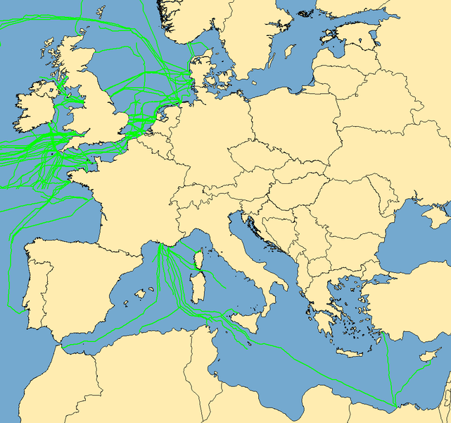
| Incazelo | Map with examples of submarine communications cables. Some of the cables represented were incomplete in the mapping stage; they do not go to "nowhere", they are merely incomplete when this image was captured. | ||
| Usuku | (UTC) | ||
| Umthombo | Data taken from public sources. Created using MapInfo Professional v8.5 and various mapping resources. | ||
| Umlobi | Rarelibra | ||
| Permission (Reusing this file) |
|
Umlando womqulu
Click on a date/time to view the file as it appeared at that time.
| Usuku/Isikhathi | Isithonjana | Dimensions | Umsebenzisi | Amazwana | |
|---|---|---|---|---|---|
| Njengamanje | 10:53, 7 uMfumfu 2019 | | 1,021 × 955 (81 KB) | Bjh21 | Reverted to version as of 19:07, 13 August 2007 (UTC): Waldyrious and User:Μυρμηγκάκι have already reverted this version, which is an objection under COM:OVERWRITE. Also the world map is already available at File:World map of submarine cables.png. |
| 03:27, 7 uMfumfu 2019 |  | 1,601 × 1,025 (74 KB) | Rarelibra | Reverted to version as of 07:57, 2 October 2008 (UTC) | |
| 13:09, 21 uZibandlela 2008 |  | 1,021 × 955 (81 KB) | Waldyrious | Reverted to original version. Other versions will be uploaded separately. | |
| 12:55, 2 uMfumfu 2008 |  | 1,025 × 614 (16 KB) | Rarelibra | Reverted to version as of 22:13, 1 February 2008 | |
| 07:57, 2 uMfumfu 2008 |  | 1,601 × 1,025 (74 KB) | Μυρμηγκάκι | Reverted to version as of 23:22, 22 August 2007 | |
| 22:13, 1 uNhlolanja 2008 |  | 1,025 × 614 (16 KB) | Rarelibra | Updated example of a submarine cable in the North Sea. The blue line depicts the ACTUAL location of the submarine cable, taken from GPS coordinates of the cable. The red line depicts the REPRESENTATIVE location of the submarine cable. | |
| 23:22, 22 uNcwaba 2007 |  | 1,601 × 1,025 (74 KB) | Rarelibra | Updated map with cables around the world. | |
| 19:07, 13 uNcwaba 2007 |  | 1,021 × 955 (81 KB) | Rarelibra | Map with examples of submarine communications cables in Europe (Mediterranean Sea, English Channel, and North Sea). Data taken from public sources for fishermen and is therefore not restricted in any sense. Created by ~~~~ for public domain use, using Map |
Ukusetshenziswa komqulu
Awekho amakhasi asebenzisa lolu hlobo lomqulu.
Ukusetshenziswa komqulu jikelele
Amanye ama-wiki asebenzisa lefayela
- Ukusetshenziswa ku-da.wikipedia.org
- Ukusetshenziswa ku-de.wikipedia.org
- Ukusetshenziswa ku-en.wikipedia.org