
File:Eswatini Regions map.png

Size of this preview: Amachashazikazi ama-524 adlulayo nama-600 amile. Other resolutions: Amachashazikazi ama-210 adlulayo nama-240 amile | Amachashazikazi ama-419 adlulayo nama-480 amile | Amachashazikazi ama-671 adlulayo nama-768 amile | Amachashazikazi ama-895 adlulayo nama-1,024 amile | Amachashazikazi ama-2,000 adlulayo nama-2,289 amile.
Ifayela ewu ngqo (2,000 × 2,289 pixels, file size: 13.12 MB, MIME type: image/png)
Isifinyezo
| Incazelo |
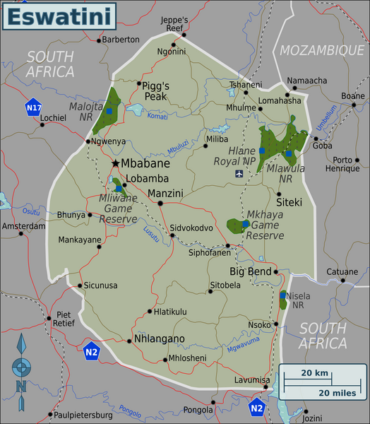
English: Map of Eswatini with regions colour coded. Map of Eswatini, Eswatini |
| Usuku | |
| Umthombo | :image:Eswatini Regions map.svg |
| Umlobi | User:(WT-shared) Burmesedays, Perry-Castañeda Library Map Collection Swaziland Maps |
Licensing
This file is licensed under the Creative Commons Attribution-Share Alike 3.0 Unported license.
- Ukhululekile:
- ukwabelana – to copy, distribute and transmit the work
- to remix – to adapt the work
- Ngaphansi kwezimo ezilandelayo:
- attribution – You must give appropriate credit, provide a link to the license, and indicate if changes were made. You may do so in any reasonable manner, but not in any way that suggests the licensor endorses you or your use.
- yabelana ngokufana – If you remix, transform, or build upon the material, you must distribute your contributions under the same or compatible license as the original.
Original upload log
| This file was imported from Wikivoyage WTS. |
The original description page was here. All following user names refer to wts.wikivoyage-old.
- 2010-03-07 09:32 (WT-shared) Burmesedays[dead link] 2486×2941 (1670211 bytes) {{Imagecredit|credit=[[User:Burmesedays]], [http://lib.utexas.edu/maps/swaziland.html Perry-Castañeda Library Map Collection Swaziland Maps (Import from wikitravel.org/shared)
- 2010-03-07 13:25 (WT-shared) Burmesedays[dead link] 2486×2941 (1685930 bytes) added SA route shields (Import from wikitravel.org/shared)
- 2010-03-08 03:40 (WT-shared) Burmesedays[dead link] 2486×2941 (1645332 bytes) with regions turned off as per talk (Import from wikitravel.org/shared)
- 2010-03-08 04:10 (WT-shared) Burmesedays[dead link] 2486×2941 (1645355 bytes) (Import from wikitravel.org/shared)
Umlando womqulu
Click on a date/time to view the file as it appeared at that time.
| Usuku/Isikhathi | Isithonjana | Dimensions | Umsebenzisi | Amazwana | |
|---|---|---|---|---|---|
| Njengamanje | 05:34, 9 uNcwaba 2020 | | 2,000 × 2,289 (13.12 MB) | Bestoernesto | Moved the International Airport to the right place |
| 19:19, 8 uNdasa 2019 |  | 2,000 × 2,289 (1.08 MB) | Shaundd | Swaziland > Eswatini, changes to improve readability, reframe map so more focus on Eswatini | |
| 01:10, 19 uZibandlela 2012 |  | 2,486 × 2,941 (1.57 MB) | OgreBot | (BOT): Reverting to most recent version before archival | |
| 01:10, 19 uZibandlela 2012 |  | 2,486 × 2,941 (1.57 MB) | OgreBot | (BOT): Uploading old version of file from wts.wikivoyage; originally uploaded on 2010-03-08 03:40:17 by (WT-shared) Burmesedays | |
| 01:10, 19 uZibandlela 2012 |  | 2,486 × 2,941 (1.61 MB) | OgreBot | (BOT): Uploading old version of file from wts.wikivoyage; originally uploaded on 2010-03-07 13:25:31 by (WT-shared) Burmesedays | |
| 01:09, 19 uZibandlela 2012 |  | 2,486 × 2,941 (1.59 MB) | OgreBot | (BOT): Uploading old version of file from wts.wikivoyage; originally uploaded on 2010-03-07 09:32:32 by (WT-shared) Burmesedays | |
| 02:57, 18 uLwezi 2012 |  | 2,486 × 2,941 (1.57 MB) | MGA73bot2 | {{BotMoveToCommons|wts.oldwikivoyage|year={{subst:CURRENTYEAR}}|month={{subst:CURRENTMONTHNAME}}|day={{subst:CURRENTDAY}}}} == {{int:filedesc}} == {{Information |description=Map of Swaziland with regions colour coded. Map of Swaziland, Swaziland * Map ... |
Ukusetshenziswa komqulu
The following page uses this file:
Ukusetshenziswa komqulu jikelele
Amanye ama-wiki asebenzisa lefayela
- Ukusetshenziswa ku-ace.wikipedia.org
- Ukusetshenziswa ku-af.wikipedia.org
- Ukusetshenziswa ku-ang.wikipedia.org
- Ukusetshenziswa ku-ary.wikipedia.org
- Ukusetshenziswa ku-ast.wikipedia.org
- Ukusetshenziswa ku-avk.wikipedia.org
- Ukusetshenziswa ku-ay.wikipedia.org
- Ukusetshenziswa ku-azb.wikipedia.org
- Ukusetshenziswa ku-az.wikipedia.org
- Ukusetshenziswa ku-ban.wikipedia.org
- Ukusetshenziswa ku-bat-smg.wikipedia.org
- Ukusetshenziswa ku-ba.wikipedia.org
- Ukusetshenziswa ku-bcl.wikipedia.org
- Ukusetshenziswa ku-bh.wikipedia.org
- Ukusetshenziswa ku-bi.wikipedia.org
- Ukusetshenziswa ku-bjn.wikipedia.org
- Ukusetshenziswa ku-bm.wikipedia.org
- Ukusetshenziswa ku-bo.wikipedia.org
- Ukusetshenziswa ku-bpy.wikipedia.org
- Ukusetshenziswa ku-br.wikipedia.org
- Ukusetshenziswa ku-bs.wikipedia.org
- Ukusetshenziswa ku-bxr.wikipedia.org
- Ukusetshenziswa ku-cbk-zam.wikipedia.org
- Ukusetshenziswa ku-cdo.wikipedia.org
- Ukusetshenziswa ku-ceb.wikipedia.org
- Ukusetshenziswa ku-ce.wikipedia.org
- Ukusetshenziswa ku-ckb.wikipedia.org
- Ukusetshenziswa ku-crh.wikipedia.org
- Ukusetshenziswa ku-cs.wikipedia.org
- Ukusetshenziswa ku-cy.wikipedia.org
- Ukusetshenziswa ku-da.wikipedia.org
- Ukusetshenziswa ku-de.wikivoyage.org
- Ukusetshenziswa ku-diq.wikipedia.org
- Ukusetshenziswa ku-dty.wikipedia.org
- Ukusetshenziswa ku-ee.wikipedia.org
- Ukusetshenziswa ku-en.wikivoyage.org
- Ukusetshenziswa ku-eo.wikipedia.org
- Ukusetshenziswa ku-fa.wikipedia.org
- Ukusetshenziswa ku-fiu-vro.wikipedia.org
- Ukusetshenziswa ku-fr.wikivoyage.org
- Ukusetshenziswa ku-fy.wikipedia.org
- Ukusetshenziswa ku-ga.wikipedia.org
- Ukusetshenziswa ku-gd.wikipedia.org
- Ukusetshenziswa ku-gl.wikipedia.org
- Ukusetshenziswa ku-he.wikivoyage.org
- Ukusetshenziswa ku-hi.wikipedia.org
- Ukusetshenziswa ku-hr.wikipedia.org
- Ukusetshenziswa ku-incubator.wikimedia.org
View more global usage of this file.