
File:Mapa del sur de España neutral.png
No higher resolution available.
Mapa_del_sur_de_España_neutral.png (795 × 455 pixels, file size: 209 KB, MIME type: image/png)

|
This map image could be re-created using vector graphics as an SVG file. This has several advantages; see Commons:Media for cleanup for more information. If an SVG form of this image is available, please upload it and afterwards replace this template with
{{vector version available|new image name}}.
It is recommended to name the SVG file “Mapa del sur de España neutral.svg”—then the template Vector version available (or Vva) does not need the new image name parameter. |
| Incazelo |
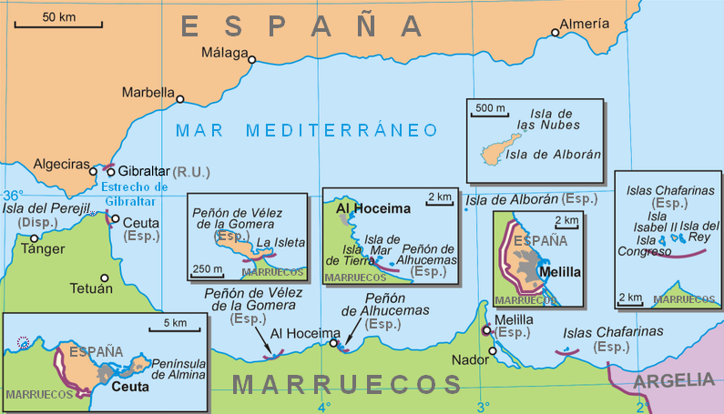
Español: Mapa del sur de España
English: Map of South Spain |
||||||||
| Usuku | |||||||||
| Umthombo | From Polish Wikipedia, translated to Spanish and neutralized. | ||||||||
| Umlobi | Ecemaml | ||||||||
| Permission (Reusing this file) |
|
||||||||
| Other versions |
|


.png)
.png)

.png)
Umlando womqulu
Click on a date/time to view the file as it appeared at that time.
| Usuku/Isikhathi | Isithonjana | Dimensions | Umsebenzisi | Amazwana | |
|---|---|---|---|---|---|
| Njengamanje | 18:39, 1 uNhlolanja 2022 | | 795 × 455 (209 KB) | Lojwe | Frame removed |
| 12:00, 17 uNtulikazi 2010 |  | 800 × 461 (218 KB) | Omar-Toons | un-cropping | |
| 13:00, 15 uNdasa 2008 |  | 800 × 461 (216 KB) | RedCoat | Reverted to version as of 16:10, 23 November 2007 | |
| 16:13, 9 uMasingana 2008 |  | 800 × 461 (206 KB) | Zeviyista | ||
| 16:10, 23 uLwezi 2007 |  | 800 × 461 (216 KB) | RedCoat | ||
| 22:15, 4 uNcwaba 2007 |  | 800 × 461 (206 KB) | Ecemaml | {{Information |Description={{es|Mapa del sur de España}} {{en|Map of South Spain}} |Source=From Polish Wikipedia, translated to Spanish and neutralized. |Date=2007-08-05 |Author= Ecemaml |Permission= |
Ukusetshenziswa komqulu
The following page uses this file:
Ukusetshenziswa komqulu jikelele
Amanye ama-wiki asebenzisa lefayela
- Ukusetshenziswa ku-af.wikipedia.org
- Ukusetshenziswa ku-an.wikipedia.org
- Ukusetshenziswa ku-ar.wikipedia.org
- Ukusetshenziswa ku-arz.wikipedia.org
- Ukusetshenziswa ku-ast.wikipedia.org
- Ukusetshenziswa ku-az.wikipedia.org
- Ukusetshenziswa ku-be-tarask.wikipedia.org
- Ukusetshenziswa ku-bg.wikipedia.org
- Ukusetshenziswa ku-bn.wikipedia.org
- Ukusetshenziswa ku-br.wikipedia.org
- Ukusetshenziswa ku-bs.wikipedia.org
- Ukusetshenziswa ku-ca.wikipedia.org
- Ukusetshenziswa ku-cs.wikipedia.org
- Ukusetshenziswa ku-da.wikipedia.org
- Ukusetshenziswa ku-de.wikipedia.org
- Ukusetshenziswa ku-de.wikivoyage.org
- Ukusetshenziswa ku-en.wikipedia.org
View more global usage of this file.