
File:Western Equatoria Map.svg

Size of this PNG preview of this SVG file: Amachashazikazi ama-800 adlulayo nama-581 amile. Other resolutions: Amachashazikazi ama-320 adlulayo nama-232 amile | Amachashazikazi ama-640 adlulayo nama-465 amile | Amachashazikazi ama-1,024 adlulayo nama-743 amile | Amachashazikazi ama-1,280 adlulayo nama-929 amile | Amachashazikazi ama-2,560 adlulayo nama-1,858 amile | Amachashazikazi ama-1,561 adlulayo nama-1,133 amile.
Ifayela ewu ngqo (SVG file, nominally 1,561 × 1,133 pixels, file size: 214 KB)
Isifinyezo
| Incazelo |
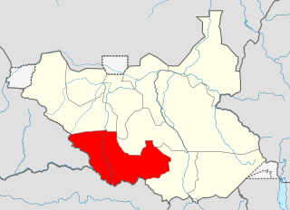
English: Map of Western Equatoria Српски / srpski: Мапа Западне Екваторије Español: Mapa de Ecuatoria Occidental.
|
||||||
| Usuku | |||||||
| Umthombo | Own work | ||||||
| Umlobi | Ivan25 | ||||||
Licensing
I, the copyright holder of this work, hereby publish it under the following license:
This file is licensed under the Creative Commons Attribution-Share Alike 3.0 Unported license.
- Ukhululekile:
- ukwabelana – to copy, distribute and transmit the work
- to remix – to adapt the work
- Ngaphansi kwezimo ezilandelayo:
- attribution – You must give appropriate credit, provide a link to the license, and indicate if changes were made. You may do so in any reasonable manner, but not in any way that suggests the licensor endorses you or your use.
- yabelana ngokufana – If you remix, transform, or build upon the material, you must distribute your contributions under the same or compatible license as the original.
Umlando womqulu
Click on a date/time to view the file as it appeared at that time.
| Usuku/Isikhathi | Isithonjana | Dimensions | Umsebenzisi | Amazwana | |
|---|---|---|---|---|---|
| Njengamanje | 02:04, 1 uLwezi 2011 | | 1,561 × 1,133 (214 KB) | Spesh531 | Dispute |
| 04:12, 9 uNtulikazi 2011 |  | 1,500 × 1,133 (244 KB) | B1mbo | New version based in File:South Sudan location map.svg | |
| 14:07, 16 uNhlangulana 2011 |  | 422 × 315 (21 KB) | Ivan25 |
Ukusetshenziswa komqulu
The following page uses this file:
Ukusetshenziswa komqulu jikelele
Amanye ama-wiki asebenzisa lefayela
- Ukusetshenziswa ku-ab.wikipedia.org
- Ukusetshenziswa ku-ar.wikipedia.org
- Ukusetshenziswa ku-bg.wikipedia.org
- Ukusetshenziswa ku-ca.wikipedia.org
- Ukusetshenziswa ku-en.wikipedia.org
- Ukusetshenziswa ku-eo.wikipedia.org
- Ukusetshenziswa ku-fi.wikipedia.org
- Ukusetshenziswa ku-fr.wikipedia.org
- Ukusetshenziswa ku-id.wikipedia.org
- Ukusetshenziswa ku-ja.wikipedia.org
- Ukusetshenziswa ku-ka.wikipedia.org
- Ukusetshenziswa ku-ko.wikipedia.org
- Ukusetshenziswa ku-lt.wikipedia.org
- Ukusetshenziswa ku-mk.wikipedia.org
- Ukusetshenziswa ku-nl.wikipedia.org
- Ukusetshenziswa ku-pl.wikipedia.org
- Ukusetshenziswa ku-pt.wikipedia.org
- Ukusetshenziswa ku-ro.wikipedia.org
- Ukusetshenziswa ku-ru.wikipedia.org
- Ukusetshenziswa ku-sr.wikipedia.org
- Ukusetshenziswa ku-sv.wikipedia.org
- Ukusetshenziswa ku-tr.wikipedia.org
- Ukusetshenziswa ku-uk.wikipedia.org
- Ukusetshenziswa ku-ur.wikipedia.org
- Ukusetshenziswa ku-vi.wikipedia.org
- Ukusetshenziswa ku-www.wikidata.org
- Ukusetshenziswa ku-zh.wikipedia.org