
File:Gabon sat.png

Size of this preview: Amachashazikazi ama-553 adlulayo nama-599 amile. Other resolutions: Amachashazikazi ama-222 adlulayo nama-240 amile | Amachashazikazi ama-443 adlulayo nama-480 amile | Amachashazikazi ama-698 adlulayo nama-756 amile.
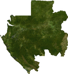
Ifayela ewu ngqo (698 × 756 pixels, file size: 615 KB, MIME type: image/png)
ECW to TIFF to PNG (compression level 9).
| This file is in the public domain, because it was generated by a user, using free sources available at The Map Library.
Note that this does not include the maps in the Global Administrative Areas section of the homepage. |
Umlando womqulu
Click on a date/time to view the file as it appeared at that time.
| Usuku/Isikhathi | Isithonjana | Dimensions | Umsebenzisi | Amazwana | |
|---|---|---|---|---|---|
| Njengamanje | 01:14, 14 uNtulikazi 2006 | | 698 × 756 (615 KB) | Unquietwiki | ECW to TIFF to PNG (compression level 9). {{PD-MapLibrary}} |
Ukusetshenziswa komqulu
The following page uses this file:
Ukusetshenziswa komqulu jikelele
Amanye ama-wiki asebenzisa lefayela
- Ukusetshenziswa ku-af.wikipedia.org
- Ukusetshenziswa ku-arz.wikipedia.org
- Ukusetshenziswa ku-ast.wikipedia.org
- Ukusetshenziswa ku-ca.wikipedia.org
- Ukusetshenziswa ku-ceb.wikipedia.org
- Ukusetshenziswa ku-dag.wikipedia.org
- Ukusetshenziswa ku-de.wikivoyage.org
- Ukusetshenziswa ku-diq.wikipedia.org
- Ukusetshenziswa ku-en.wikipedia.org
- Ukusetshenziswa ku-en.wikinews.org
- Ukusetshenziswa ku-fa.wikipedia.org
- Ukusetshenziswa ku-ff.wikipedia.org
- Ukusetshenziswa ku-fr.wikipedia.org
- Ukusetshenziswa ku-fr.wikinews.org
- Ukusetshenziswa ku-fr.wikivoyage.org
- Ukusetshenziswa ku-ga.wikipedia.org
- Ukusetshenziswa ku-gd.wikipedia.org
- Ukusetshenziswa ku-gl.wikipedia.org
- Ukusetshenziswa ku-gpe.wikipedia.org
- Ukusetshenziswa ku-ha.wikipedia.org
- Ukusetshenziswa ku-he.wikivoyage.org
- Ukusetshenziswa ku-hr.wikipedia.org
- Ukusetshenziswa ku-ia.wikipedia.org
- Ukusetshenziswa ku-id.wikipedia.org
- Ukusetshenziswa ku-ig.wikipedia.org
- Ukusetshenziswa ku-is.wikipedia.org
- Ukusetshenziswa ku-kab.wikipedia.org
- Ukusetshenziswa ku-ka.wikipedia.org
- Ukusetshenziswa ku-lt.wikipedia.org
- Ukusetshenziswa ku-pap.wikipedia.org
- Ukusetshenziswa ku-sv.wikipedia.org
- Ukusetshenziswa ku-tum.wikipedia.org
- Ukusetshenziswa ku-ur.wikipedia.org
- Ukusetshenziswa ku-vec.wikipedia.org
- Ukusetshenziswa ku-www.wikidata.org