
File:Map of the National Roads of South Africa with labels.svg

Size of this PNG preview of this SVG file: Amachashazikazi ama-684 adlulayo nama-599 amile. Other resolutions: Amachashazikazi ama-274 adlulayo nama-240 amile | Amachashazikazi ama-548 adlulayo nama-480 amile | Amachashazikazi ama-876 adlulayo nama-768 amile | Amachashazikazi ama-1,168 adlulayo nama-1,024 amile | Amachashazikazi ama-2,337 adlulayo nama-2,048 amile | Amachashazikazi ama-809 adlulayo nama-709 amile.
Ifayela ewu ngqo (SVG file, nominally 809 × 709 pixels, file size: 547 KB)
Isifinyezo
| Incazelo |
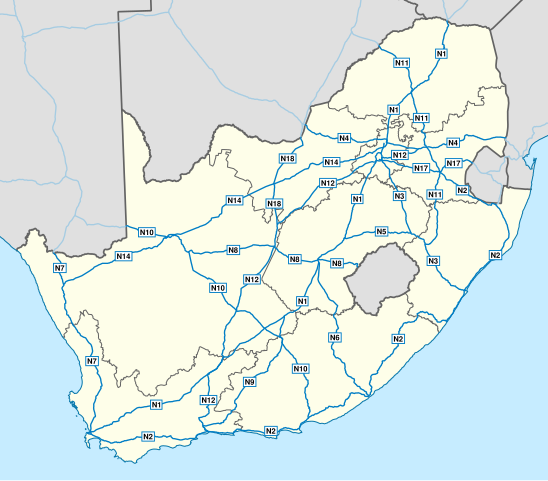
English: Map of South Africa showing the roads of the National Route System, with labels. |
| Usuku | |
| Umthombo | Geodata from OpenStreetMap |
| Umlobi | Htonl |
| Other versions | File:Map of the National Roads of South Africa.svg, File:Map of the National Roads of South Africa with labels and cities.svg |
| SVG genesis |
Licensing
This file is licensed under the Creative Commons Attribution-Share Alike 3.0 Unported license.
- Ukhululekile:
- ukwabelana – to copy, distribute and transmit the work
- to remix – to adapt the work
- Ngaphansi kwezimo ezilandelayo:
- attribution – You must give appropriate credit, provide a link to the license, and indicate if changes were made. You may do so in any reasonable manner, but not in any way that suggests the licensor endorses you or your use.
- yabelana ngokufana – If you remix, transform, or build upon the material, you must distribute your contributions under the same or compatible license as the original.
| This work contains information from OpenStreetMap, which is made available under the Open Database License (ODbL).
The ODbL does not require any particular license for maps produced from ODbL data. Prior to 1 August 2020, map tiles produced by the OpenStreetMap Foundation were licensed under the CC-BY-SA-2.0 license. Maps produced by other people may be subject to other licences. |
Umlando womqulu
Click on a date/time to view the file as it appeared at that time.
| Usuku/Isikhathi | Isithonjana | Dimensions | Umsebenzisi | Amazwana | |
|---|---|---|---|---|---|
| Njengamanje | 18:45, 1 uNhlolanja 2014 | | 809 × 709 (547 KB) | Htonl | update w/ simpler labels, roads in neighbouring countries, ODbL data |
| 19:51, 10 uZibandlela 2010 |  | 757 × 660 (1.08 MB) | Htonl | use appropriate projection; change basemap style | |
| 03:19, 21 uMbasa 2010 |  | 1,000 × 786 (1.5 MB) | Htonl | minor SVG tweak | |
| 03:11, 21 uMbasa 2010 |  | 1,000 × 786 (1.5 MB) | Htonl | new version based on OSM data | |
| 21:26, 23 uNtulikazi 2009 |  | 1,000 × 786 (2.14 MB) | Htonl | minor tweaks | |
| 20:25, 23 uNtulikazi 2009 |  | 1,000 × 786 (2.13 MB) | Htonl | colours, labels, widths | |
| 18:05, 6 uLwezi 2008 |  | 1,000 × 786 (2.08 MB) | Htonl | {{Information |Description={{en|1=Map of South Africa showing the roads of the National Road System, with labels.}} |Source=Own work by uploader |Author=Htonl |Date=2008-11-06 |Permission= |other_versions=[[:Image:Map of the National Roads |
Ukusetshenziswa komqulu
The following page uses this file:
Ukusetshenziswa komqulu jikelele
Amanye ama-wiki asebenzisa lefayela
- Ukusetshenziswa ku-af.wikipedia.org
- Ukusetshenziswa ku-de.wikipedia.org
- Ukusetshenziswa ku-en.wikipedia.org
- Ukusetshenziswa ku-en.wikivoyage.org
- Ukusetshenziswa ku-fr.wikipedia.org
- Ukusetshenziswa ku-fy.wikipedia.org
- Ukusetshenziswa ku-it.wikipedia.org
- Ukusetshenziswa ku-ja.wikipedia.org
- Ukusetshenziswa ku-nl.wikipedia.org
- Ukusetshenziswa ku-ro.wikipedia.org
- Ukusetshenziswa ku-uk.wikipedia.org