
File:Oruzgan districts.png
Size of this preview: Amachashazikazi ama-787 adlulayo nama-600 amile. Other resolutions: Amachashazikazi ama-315 adlulayo nama-240 amile | Amachashazikazi ama-630 adlulayo nama-480 amile | Amachashazikazi ama-1,000 adlulayo nama-762 amile.
Ifayela ewu ngqo (1,000 × 762 pixels, file size: 17 KB, MIME type: image/png)

|
This map image could be re-created using vector graphics as an SVG file. This has several advantages; see Commons:Media for cleanup for more information. If an SVG form of this image is available, please upload it and afterwards replace this template with
{{vector version available|new image name}}.
It is recommended to name the SVG file “Oruzgan districts.svg”—then the template Vector version available (or Vva) does not need the new image name parameter. |
Isifinyezo
| Incazelo |
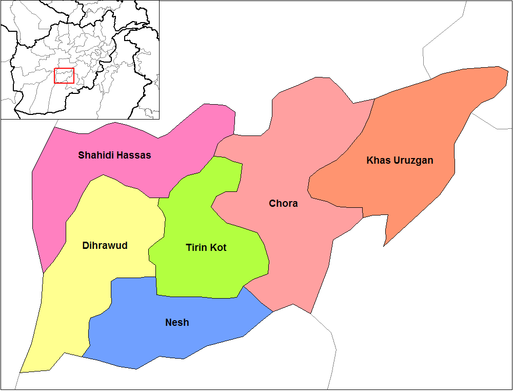
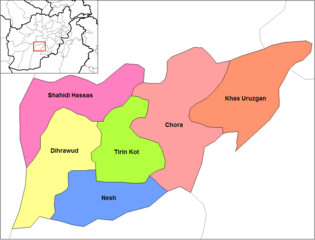
English: Map of the districts of Oruzgan province of Afghanistan. Created by Rarelibra 19:31, 29 March 2007 (UTC) for public domain use, using MapInfo Professional v8.5 and various mapping resources. |
| Usuku | 29 uNdasa 2007 (original upload date) |
| Umthombo | No machine-readable source provided. Own work assumed (based on copyright claims). |
| Umlobi | No machine-readable author provided. Rarelibra assumed (based on copyright claims). |
Licensing
| I, the copyright holder of this work, release this work into the public domain. This applies worldwide. In some countries this may not be legally possible; if so: I grant anyone the right to use this work for any purpose, without any conditions, unless such conditions are required by law. |
Umlando womqulu
Click on a date/time to view the file as it appeared at that time.
| Usuku/Isikhathi | Isithonjana | Dimensions | Umsebenzisi | Amazwana | |
|---|---|---|---|---|---|
| Njengamanje | 18:59, 14 uNhlolanja 2024 | | 1,000 × 762 (17 KB) | User-duck | Cropped 5 % horizontally, 7 % vertically using CropTool with lossless mode. |
| 19:31, 29 uNdasa 2007 |  | 1,056 × 816 (25 KB) | Rarelibra | Map of the districts of Oruzgan province of Afghanistan. Created by ~~~~ for public domain use, using MapInfo Professional v8.5 and various mapping resources. |
Ukusetshenziswa komqulu
The following page uses this file:
Ukusetshenziswa komqulu jikelele
Amanye ama-wiki asebenzisa lefayela
- Ukusetshenziswa ku-ar.wikipedia.org
- Ukusetshenziswa ku-ca.wikipedia.org
- Ukusetshenziswa ku-da.wikipedia.org
- Ukusetshenziswa ku-de.wikipedia.org
- Ukusetshenziswa ku-de.wikinews.org
- Ukusetshenziswa ku-en.wikipedia.org
- Ukusetshenziswa ku-es.wikipedia.org
- Ukusetshenziswa ku-fr.wikipedia.org
- Ukusetshenziswa ku-he.wikipedia.org
- Ukusetshenziswa ku-incubator.wikimedia.org
- Ukusetshenziswa ku-it.wikipedia.org
- Ukusetshenziswa ku-ja.wikipedia.org
- Ukusetshenziswa ku-lt.wikipedia.org
- Ukusetshenziswa ku-mn.wikipedia.org
- Ukusetshenziswa ku-ms.wikipedia.org
- Ukusetshenziswa ku-nl.wikipedia.org
- Ukusetshenziswa ku-no.wikipedia.org
- Ukusetshenziswa ku-pnb.wikipedia.org
- Ukusetshenziswa ku-ps.wikipedia.org
- Ukusetshenziswa ku-pt.wikipedia.org
- Ukusetshenziswa ku-ru.wikipedia.org
- Ukusetshenziswa ku-sk.wikipedia.org
- Ukusetshenziswa ku-ta.wikipedia.org
- Ukusetshenziswa ku-tr.wikipedia.org
- Ukusetshenziswa ku-uk.wikipedia.org
- Ukusetshenziswa ku-ur.wikipedia.org
- Ukusetshenziswa ku-uz.wikipedia.org
- Ukusetshenziswa ku-vi.wikipedia.org
- Ukusetshenziswa ku-www.wikidata.org